Barefoot Yacht Charters
  • Home
  • Our Fleet
  • Charters
    • Charter Prefrence
      • Bareboat
      • Skippered
      • Long Term Charters
      • Sailing School
    • Barefoot Experiences
      • Adventure
      • Romance
      • Endless Summer
      • Family Sailing
    • About The Grenadines
      • Why Start Here?
      • Geography
      • Weather
      • Services
    • Your Yacht in SVG
      • General Inventory
      • Extras/Add-ons
      • Provisioning
      • Watersports
  • Specials
  • About Us
    • Barefoot Base
      • Accommodation
      • Location
      • Marina
      • Watersports
    • Barefoot Family
      • Reservations and Customer Service
      • Marine Services
      • Turnaround Team
      • The Barnards
    • General Information
      • Driftwood Restaurant
      • Location – How to Get Here
      • Media Gallery
      • Sailing School
  • Yacht Ownership
    • Barefoot Yacht Management
    • Ownership Offers
    • Barefoot’s Guides for Prospective Charter Yacht Owners
  • News
  • Contact Us
  • Menu Menu
  • Facebook
  • Twitter
  • Youtube
  • Pinterest
  • About The Grenadines

    Geography

PreviousNext
1234

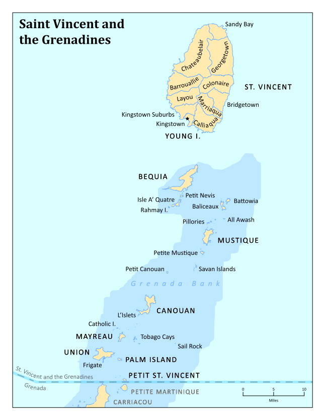
Saint Vincent and the Grenadines is an island state in the Windward Islands of the Lesser Antilles, an island arc of the Caribbean Sea in North America.

The country consists of the main island of Saint Vincent and the northern two-thirds of the Grenadines, a chain of small islands stretching south from Saint Vincent to Grenada.

Its total land area is 390 km² of which 342.7 km² is the main island of Saint Vincent. The country’s capital is at Kingstown on Saint Vincent.

  • Northernmost point: Porter Point
  • Southernmost point: Petit Saint Vincent
  • Westernmost point: Union Island, Grenadines Parish
  • Easternmost point: Battowia island, Grenadines Parish

The main island of Saint Vincent and the Grenadines is Saint Vincent. Its geography is mostly mountainous and includes very little level ground. There is also a large difference between the coastlines on each side of the island. The windward side is very rocky, while the leeward side consists of many sandy beaches and has many more bays. The island’s as well as the country’s highest peak is the volcanic Soufrière at 1,234 m. There are several tiny islets offshore of Saint Vincent including Young Island and the Cow And Calves Islands.

Subscribe to the Barefoot Newsletter and download our FREE Caribbean Packing Checklist

Barefoot Location

Barefoot Recent News

  • Virgin Atlantic – Direct flights from London Heathrow to St Vincent November 23, 2020
  • Yacht of the Month Ti Punch! October 1, 2020
  • St Vincent and the Grenadines Covid Free July 3, 2020
  • Official Government Protocol PDF June 19, 2020
  • Barefoot’s Catamaran “Viewfinder” in the ARC Race December 10, 2019

Barefoot News

  • Featured (6)
  • Featured Yachts (2)
  • General (27)
  • Health and Wellness (5)
  • News (27)
  • Ownership (7)
  • Sailing School (7)
  • Sailing the Grenadines (23)
  • Specials (10)
  • Virgin Atlantic – Direct flights from London Heathrow to St VincentNovember 23, 2020 - 4:33 pm
  • Yacht of the Month Ti Punch!October 1, 2020 - 5:28 pm
  • St Vincent and the Grenadines Covid FreeJuly 3, 2020 - 4:02 pm
  • Official Government Protocol PDFJune 19, 2020 - 12:08 pm
© Copyright 2019 - Barefoot Bareboat Yacht Charters | Powered by Coast Internet Publishing
  • Facebook
  • Twitter
  • Youtube
  • Pinterest
  • The Barefoot Companies
  • Barefoot Offshore Sailing School
  • Barefoot Performance Sailing
Scroll to top